While our efforts have continued to be focused on building and testing our statistical framework, we are also now starting to obtain some ‘real’ results.
As reported last month, it is crucial that our Bayesian Hierarchical Model (BHM) – the statistical framework that is fundamental to the project – is set-up correctly. As our confidence in its performance increases, the results it gives us start to become more interesting in their own right. With the framework now operating reliably on a global grid, our attention turned to how it might help us investigate (and hopefully ultimately improve) global estimates of glacial isostatic adjustment (GIA).
GIA is the viscous response of the solid Earth to past ice-loading and makes an important contribution to contemporary sea level changes at a regional scale. By using our BHM to combine GPS data and the ICE-6G GIA forward model, we can identify statistically significant deviations between what the observations and the model are telling us.
To do this, we have created a bespoke GPS dataset. Starting with GPS data from the Nevada Geodetic Laboratory (NGL), we undertook additional post-processing to: (1) select GPS stations that provide reliable time series; (2) automatically detect and remove outliers from these series; and (3) correct for the elastic response of Earth’s crust to present-day surface mass loading for GPS stations in Antarctica and Greenland.
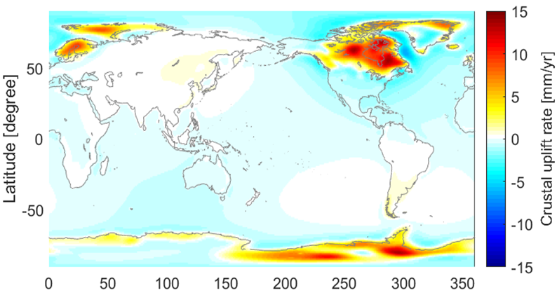
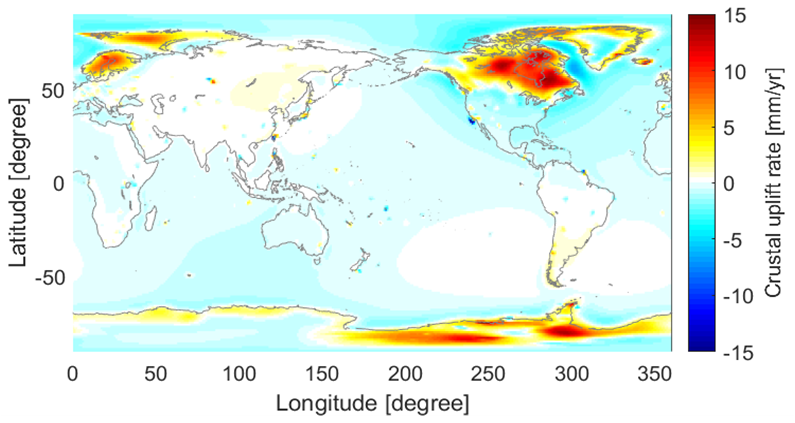
After incorporating the GPS data into the BHM, we have been able to compare estimated rates of vertical land movement. The plots below show (a) uplift rates from the ICE-6G GIA forward model and (b) uplift rates from our BHM solution. It is important to keep in mind that while the BHM results in (b) are informed by certain parameters of the ICE-6G GIA model, the final uplift rates are calculated using the GPS data, and are independent of modelled values.

(a) Uplift rates from the ICE-6G GIA forward model

(b) Uplift rates from our BHM
Overall, our first global BHM solution for GIA uplift rates shows good agreement with the ICE-6G GIA model. The main discrepancies are along the coast of Greenland and over the Ronne and Ross Ice Shelves in Antarctica. This pattern is not unexpected given that the ICE-6G is known to be problematic over Antarctica and Greenland.
While this is a useful first result, and one that reinforces our confidence in the statistical framework, we know that we can further improve the GPS dataset to provide further refinements to the GIA solution. This is a target over the coming months.
Latest outputs
A new paper by Stefan Hofer and Jonathan Bamber and others (‘Decreasing cloud cover drives the recent mass loss on the Greenland Ice Sheet’) was published in Science Advances in June. We also produced a plain language summary for our website. The paper received considerable press coverage, including in Newsweek, USA Today and Climate Central.
Zhe Sha presented a poster about the GlobalMass project at the 3rd UCL Workshop on the Theory of Big Data in London.

